Inspired
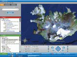
Google Earth is great. For those that haven’t seen it, Google Earth downloads on to your PC from the Web. It’s an animated 3D globe, overlaid with all sorts of information, including detailed satellite imagery of every conceivable place on our planet, as photographed from space.
You can go everywhere from your home town to the Forbidden City. Google Earth is overlaid with major roads, place names and points of reference, all in 3D. It is truly ambitious – its goal is to collect every piece of information that can be attached to a location and allow us to access it.
I once saw a group of friends form a queue to try it out for the first time. Seeing your own house (always a first call) seems to be a revelation. Non-computer-users suddenly become experts at zooming, scrolling and tilting to get the best view of their next holiday destination.
In the days of my education, information design was a dry, humourless subject, and it still has that stigma. When I see children and mothers engrossed in this explicitly informative tool, I’m reminded that much of design is now about the power of access. Google Earth has made information playful, play educational and education immersive – all things I still aspire to.
Neil Churcher
Interaction Design Institute Ivrea
-
Post a comment


